TriniTuner.com | Latest Event:


Moderator: 3ne2nr Mods


shake d livin wake d dead wrote:interesting week, next week
shake d livin wake d dead wrote:shake d livin wake d dead wrote:interesting week, next week
one to the extreme right...is now orange
shake d livin wake d dead wrote:interesting week, next week
shake d livin wake d dead wrote:Yup....that looking to surely pass through^I say by sunday - monday
shake d livin wake d dead wrote:Dem pumps yes...dem pumps

Heading north of us no need to worrybluefete wrote:shake d livin wake d dead wrote:interesting week, next weekshake d livin wake d dead wrote:Yup....that looking to surely pass through^I say by sunday - mondayshake d livin wake d dead wrote:Dem pumps yes...dem pumps
Sunday-Monday will be VERY interesting. We might really need those pumps then.
PariaMan wrote:Heading north of us no need to worrybluefete wrote:shake d livin wake d dead wrote:interesting week, next weekshake d livin wake d dead wrote:Yup....that looking to surely pass through^I say by sunday - mondayshake d livin wake d dead wrote:Dem pumps yes...dem pumps
Sunday-Monday will be VERY interesting. We might really need those pumps then.
shake d livin wake d dead wrote::|
From yellow to orange

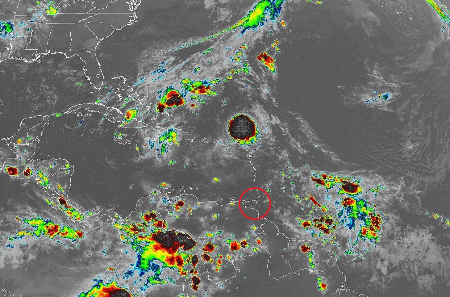
Sundar wrote:https://www.weathernerds.org/satellite/?initsatsrc=On&initsatname=GOES16&initsattype=ir&initcscheme=ir1&initimdimx=1050&initimdimy=622&initrange=20.154373928000:-69.160000000036:.428816466600:-29.354285714368&initloop=True&initnframes=30&initlightning16=On&initlightning17=Off&initltngfed=Off&initltngtoe=Off&initinterstates=On&initwarnings=On&initlatlon=Off&initascata=Off&initascatb=Off
ADVERSE WEATHER ALERT #1 - YELLOW LEVEL (Issued on Friday 20th September 2019)
Adverse Weather - Sun, Sep 22, 2019 6:00 AM to Mon, Sep 23, 2019 8:00 PM
Status - Actual
Message Type - Alert
Alert - Adverse Weather
Response - Prepare
Urgency - Expected
Severity - Severe
Certainty - Possible
Category - Met
Start date (local time) Sun, Sep 22, 2019 6:00 AM
End date (local time) Mon, Sep 23, 2019 8:00 PM
Headline ADVERSE WEATHER ALERT #1 - YELLOW LEVEL (Issued on Friday 20th September 2019)
Description
There is medium (40-60%) chance of heavy to intense showers and/or thunderstorms developing from Sunday morning. Significant rainfall will continue into Monday. Heavy/intense downpours will lead to street/flash flooding. Gusty winds in excess of 65 km/hr can be expected. The risk of landslides/landslips is very high in areas so prone.
Instructions
Adequate preparations should be made to safeguard life and property. Create a safety plan in case of emergency. Monitor updates from the OFFICIAL WEATHER SOURCE, the Trinidad and Tobago Meteorological Service (TTMS) at http://www.metoffice.gov.tt. For additional information on instructions, visit http://www.odpm.gov.tt
Area description
Trinidad & Tobago
An area of disturbed weather with medium chances of developing into a tropical cyclone is forecast to move across Trinidad, Tobago and the Southern Windwards this weekend into early next week.
This system is forecast to bring rain, showers, and thunderstorms.
This activity is forecast to produce copious amounts of rainfall beginning by late Saturday, lingering through Tuesday.
An Adverse Weather Alert (Yellow Level) will go into effect 6 am Sunday through 8 pm Monday when the most intense activity is forecast.
This heavy and prolonged rainfall is forecast to trigger street, flash and even possible riverine flooding across Trinidad and Tobago Sunday through Monday.
This heavy rainfall may also be accompanied by gusty winds, at times above 65 kilometres per hour.
Wind gusts at this strength can down trees, utility poles, and lines which may block roads and cause localized power outages.
Roof damage may also occur.
Seas are also forecast to be affected, becoming moderate to rough between late Saturday through early Tuesday, with waves up to 4.0 meters in open waters.
Waves and swells are forecast to batter Northern and Eastern coastlines of Trinidad, posing a threat to mariners and marine interests.
Speaking to Guardian Media, Jerry David, the senior disaster management unit coordinator for the Ministry of Rural Development and Local Government, he said that all corporations across the country had been placed on alert Friday afternoon.
According to David, corporations were instructed to preposition equipment, vehicles, and supplies to move in a state of readiness as this strong weather system nears T&T.
Although the corporations across Trinidad and Tobago are in a state of readiness, David reiterated that the onus of preparedness is on the individual.
The Trinidad and Tobago Meteorological Service has advised that adequate preparations should be made to safeguard life and property and persons should create a safety plan in case of emergency in their alert.
http://www.guardian.co.tt/news/adverse- ... 5da0107030

hustla_ambition101 wrote:May very well veer north......

Return to “Ole talk and more Ole talk”
Users browsing this forum: No registered users and 112 guests